Sign up to receive quotes
Khách Sạn Và Biệt Thự Ven Sông Cross Hội An

 Close
Close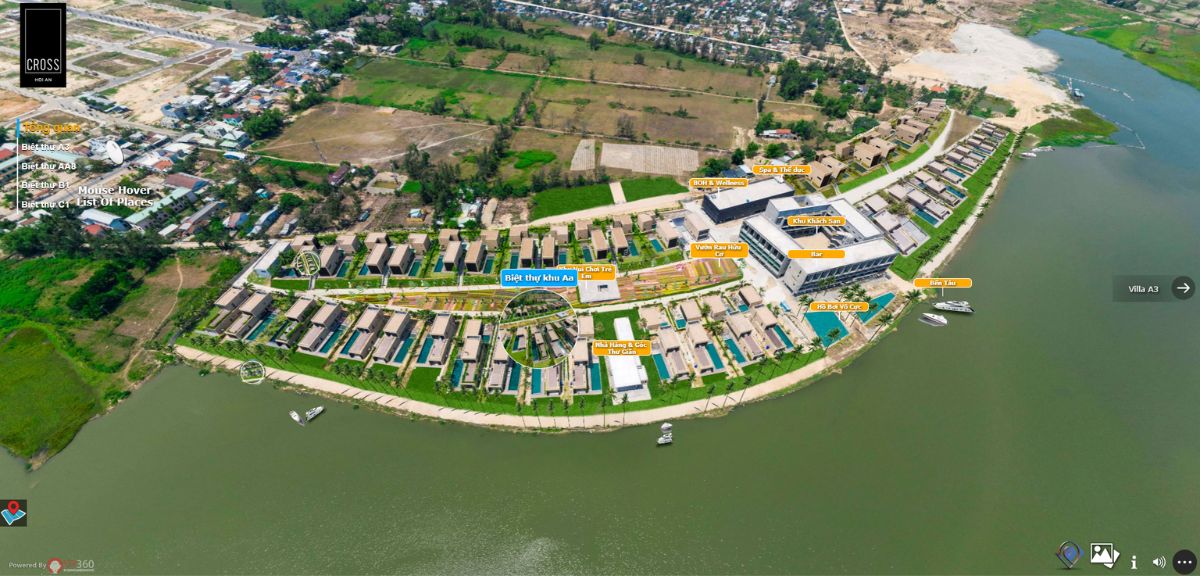
LIÊN HỆ HỢP TÁC CÙNG VR360
VR360 – ĐỔI MỚI ĐỂ KHÁC BIỆT
- Fb: https://www.facebook.com/vr360vnvirtualtour/
- Hotline: 0935 690 369
- Email: infor@vr360.com.vn
- Địa chỉ:
- 123 Phạm Huy Thông, Sơn Trà, Đà Nẵng
- Toà nhà Citilight, số 45 Võ Thị Sáu, Đakao, Quận 1, TP Hồ Chí Minh
- 3B Đặng Thái Thân, Phan Chu Trinh, Hoàn Kiếm, Hà Nội
Frequently Asked Questions
1. What is VR360 Virtual Tour?
VR360 Virtual Tour is a virtual tour created by combining 360-degree images. Through this perspective, users have the opportunity to explore the entire real-space panorama of an accurate and detailed virtual model.
2. How to create a VR360 Virtual Tour?
It is created using 360-degree images, 360-degree videos, or 3D rendering techniques to recreate a realistic digital environment. Users can interact and navigate within the virtual tour using a mouse, keyboard, or touch on mobile devices.
3. Should I use VR360 Virtual Tour or Matterport 3D Scanning?
Depending on the space conditions and the application field, you can consider choosing one of the two options. Matterport 3D Scanning is preferred for enclosed spaces, with small to medium-sized areas, and its resources are stored and operated on the third-party Matterport Cloud. VR360 Virtual Tour can be used in both small and large spaces, especially suitable for spaces with an overhead view like virtual models. The resources are owned by you. If you're in the tourism, industrial zones, schools, or real estate sectors, VR360 Virtual Tour would be a better choice due to its features that are ideal for large spaces, allowing customization of colors to make the product more appealing. For enclosed spaces like showrooms or museums, both technologies can be used effectively.
4. How long does it take to complete a VR360 Virtual Tour?
Depending on the scale and specific requirements of the project, the time to complete a VR360 Virtual Tour will vary, typically ranging from 10 to 60 days. Please contact our hotline at 0935690369 for detailed consultation.
5. What is a virtual model?
A virtual model (also known as a virtual map or virtual model) is a technology that allows users to view and interact with a map or geographic area through a computer interface or mobile device. A virtual model provides users with an interactive and visual experience of geographical information, including location data, images, landmarks, routes, and other details. This technology is widely used in fields such as construction, real estate, and related industries to create a 3D chart or visual model of a specific project or area. The primary goal of a virtual model is to display and replicate a project in a lively manner to help viewers better understand the details and information related to that project.
6. What is a virtual model in real estate?
A virtual model in real estate is a technology that allows users to view and interact with a map or 3D simulation of a real estate project through a computer or mobile device interface. The virtual model provides clients and investors with a visual way to explore and learn about the real estate project, including location, design, amenities, and other relevant information. This technology enhances interactivity and encourages property purchase decisions based on accurate and visual information.
Typical customers


Sign up to receive information from VR360
Business License Registration Address: 63 Phan Dang Luu, Hoa Cuong Nam Ward, Hai Chau District, Da Nang City, Vietnam